
Polar solar eclipse
The total solar eclipse of December 4, 2021 visits only the continent of Antarctica during the austral Summer. Six months prior, the annular solar eclipse of June 10, 2021 began in southern Canada, traversed Greenland, and passed over the North Pole, before ending over eastern Siberia. So the year of 2021 is neatly bracketed by two polar solar eclipses!

The maximum duration of this total solar eclipse is just short of 2 minutes. Despite the short duration and remote location, hundreds of dedicated eclipse chasers will travel to catch a glimpse of the magnificent corona of the Sun, visible only during a total solar eclipse.
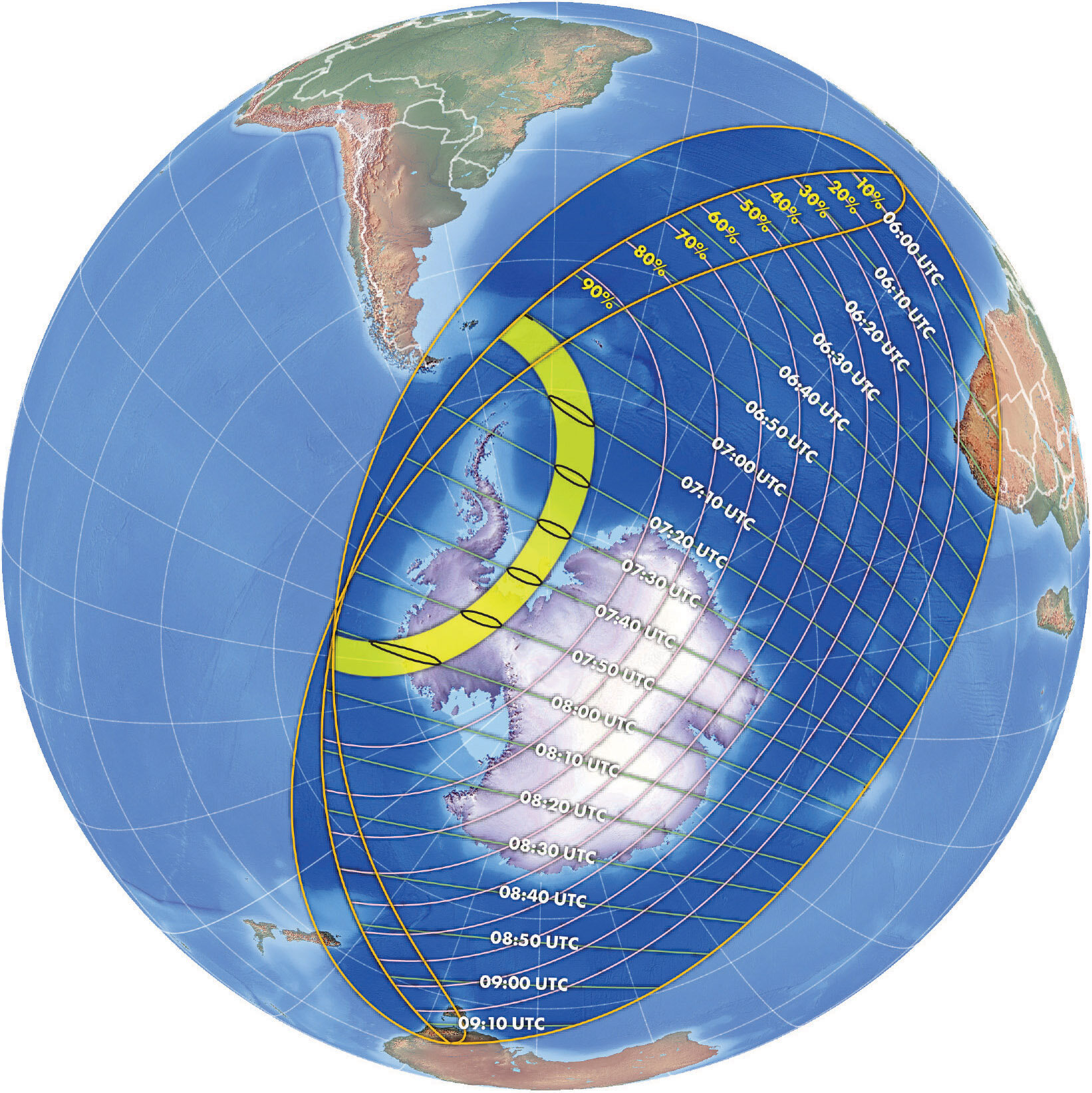
Orthographic view of the December 4 2021 eclipse from our Atlas of Solar Eclipses - 2020 to 2045.
The total solar eclipse begins at sunrise at approximately 7:00 UTC and ends just after 8:00 UTC. The zone of penumbral (partial) eclipse covers the Antarctic continent and touches only small southernmost sections of South America, Africa, New Zealand, and Australia.
We list some recommended resources for this eclipse at the bottom of this page.
Possibilities for eclipse chasers
The entire path of this total solar eclipse crosses over the newly designated Southern Ocean and Antarctica. This eclipse path is well out of any commercial shipping or airline routes, so access will be difficult and expensive. There are several possibilities to directly experience this eclipse:
At least a dozen ships operated by Antarctic expedition companies will sail to the path of totality between the Antarctic Peninsula and South Georgia Island. For aficionados of Antarctic adventure who can afford the journey, this will be an excellent opportunity to combine a visit to the White Continent with nature’s greatest sight.
At least one flight will operate from Punta Arenas, Chile to transport eclipse chasers to near the sunrise line of eclipse to view totality from 38,000 feet. After eclipse, the flight will return to Punta Arenas.
A select group of eclipse tourists will fly from Puntas Arenas and touch down at Union Glacier at 79 degrees South on the Antarctic continent. Besides the adventure of visiting the Antarctic interior, this group has great weather prospects to view the Sun’s corona at a low sky altitude.
A few naturalists and scientists are stationed at the South Orkney Islands, just inside the path of totality at 61 degrees South. It is unlikely that any eclipse tourists will visit these islands because of the environmental sensitivity of this remote archipelago.
The weather odds vary considerably among these four possibilities. The most likely to view the Sun’s corona will be those on an eclipse flight and the few at Union Glacier. At sea, the weather prospects are dim but eclipse travelers on ships are advised to consider a successful viewing of the corona as a bonus to the bucket-list adventure of visiting Antarctica.
The perspective map below gives an overview of the region of the path of total solar eclipse most likely to be visited by the few eclipse tourists embarking on this journey. The key embarkation points for most travelers will be Puntas Arenas, Chile and Ushuaia, Argentina.
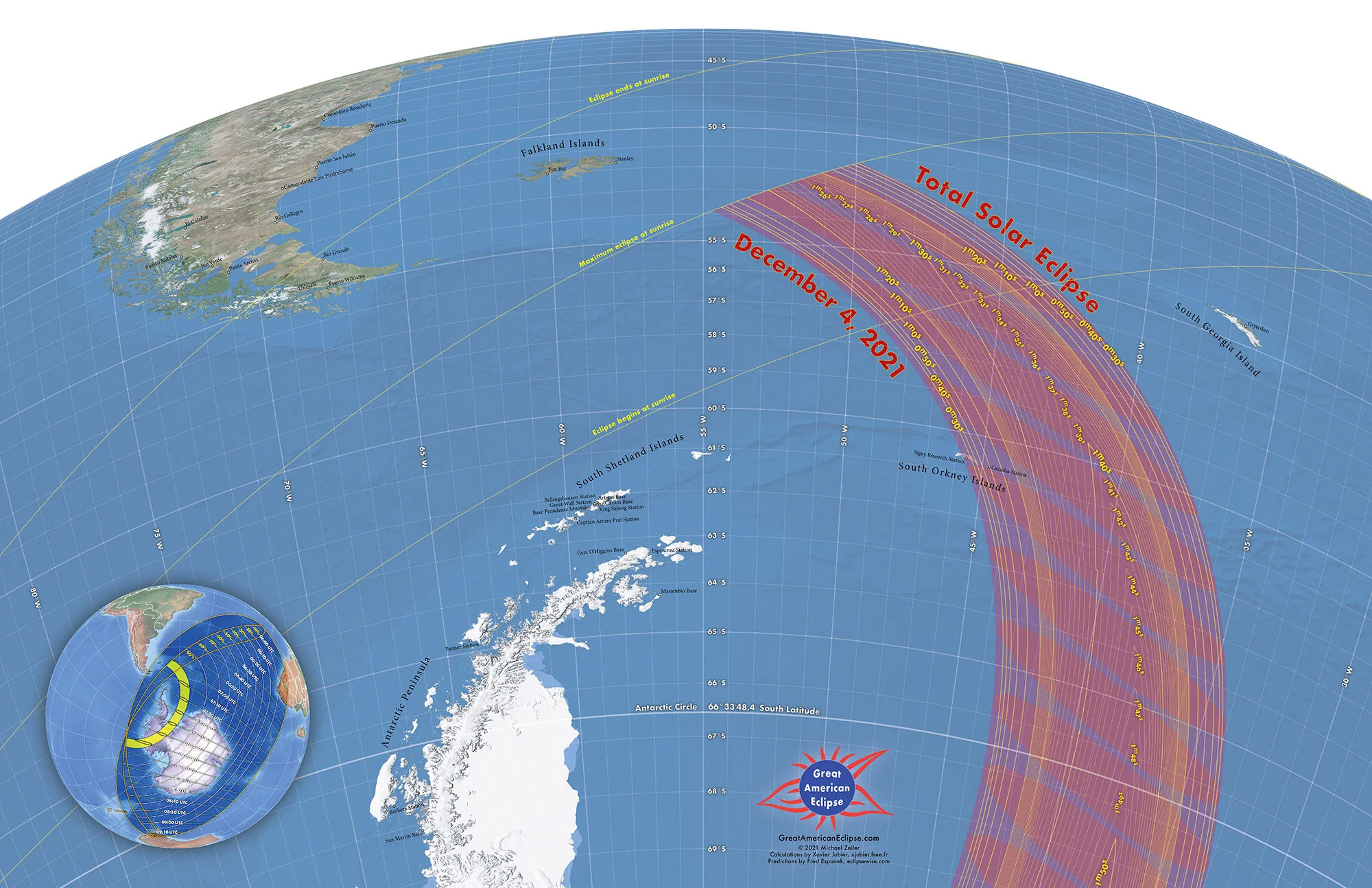
Perspective view of the total solar eclipse between the Antarctic Peninsula and South Georgia Island. For a high-resolution image of this map, email us at greatamericaneclipse@gmail.com
Nearly all eclipse flights and ships will travel to the upper section of the path of totality on this map. This navigation map is specially designed for ship operators to determine an optimal viewing site based on the detailed latitude and longitude grid lines shown here. This map and the prior overview map are designed to be printed at poster scale and this website can only display a reduced version. If you wish the original poster-resolution map, email us at greatamericaneclipse@gmail.com.
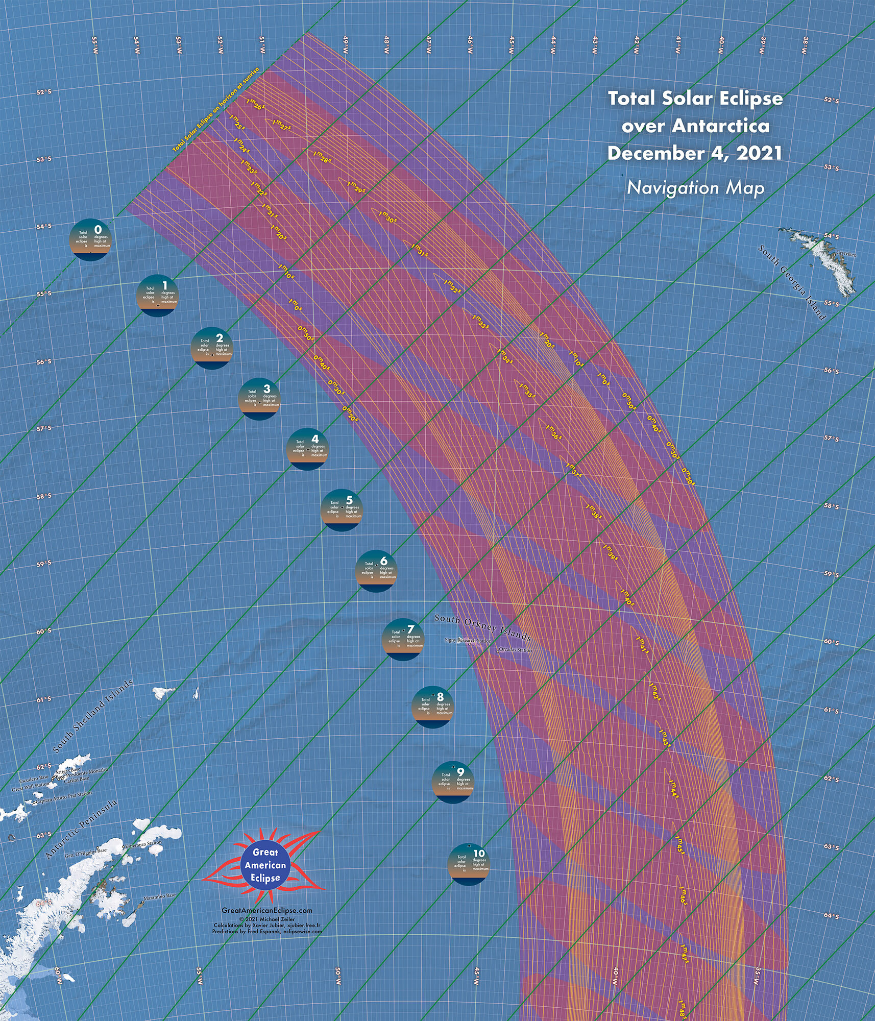
Navigation map of the total solar eclipse. For a high-resolution image of this map, email us at greatamericaneclipse@gmail.com
The eclipse begins at sunrise at the right side (below the Falkland Islands) and ends at sunset on the left side of this map.
The map displays the shadow of the Moon at 2 minute intervals. Because of the low latitudes of the Antarctic region, the Sun appears at a low sky altitude and this explains the elongated shape of the shadows, especially at sunrise and sunset.
This below maps are taken from our Atlas of Solar Eclipses - 2020 to 2045.

Map of the December 4 2021 eclipse from our Atlas of Solar Eclipses - 2020 to 2045
The following map displays the main Antarctic stations on the continent with their maximum degree of eclipse obscuration.

Eclipse circumstances and Map of the December 4 2021 eclipse from our Atlas of Solar Eclipses - 2020 to 2045
These are the brighter stars and planets that might be visible during totality. Because this eclipse is short duration, the eclipsed sky will be lighter than usual so most of these stars may not be visible. Also note that because of the low sky altitude, the lower part of this chart will be below the horizon.

Recommended resources
These are webpages with more information on the December 4, 2021 total solar eclipse.
eclipsewise.com/solar/SEprime/2001-2100/SE2021Dec04Tprime.html contains detailed predictions of this eclipse and is operated by retired NASA astrophysicist Fred Espenak. Fred’s eclipse prediction data are a foundational basis for the eclipse maps on this page.
xjubier.free.fr/en/site_pages/solar_eclipses/TSE_2021_GoogleMapFull.html is an excellent interactive online map for this eclipse created by Xavier Jubier. Xavier kindly adapted his Solar Eclipse Maestro software to create computations on which the eclipse maps on this page were created.
eclipsophile.com/2021tse/ serves authoritative climatological and weather data to guide eclipse expeditions. The number one concern of every eclipse chaser is the weather outlook and on this site, retired meteorologist and eclipse chaser Jay Anderson gives his guidance to maximum your odds on eclipse day.
whenisthenexteclipse.com/category/future-eclipses/ is run by prolific journalist and eclipse chaser Jamie Carter. He has written many accessible stories for the public on media sites such as Forbes, Sky & Telescope, Travel + Leisure, The Guardian, BBC Sky at Night, and South China Morning Post.
eclipse.aas.org is the eclipse website of the American Astronomical Society. This website is packed with scientific background, basics of eclipses, advice for observing, and how to safely view solar eclipses.
eclipse2024.org is a comprehensive website with simulations and detailed information for coming solar eclipses.
eclipses.info is the eclipse portal site of the International Union of Astronomy (IAU) Working Group for Solar Eclipses.