Finding the Double Diamond Ring
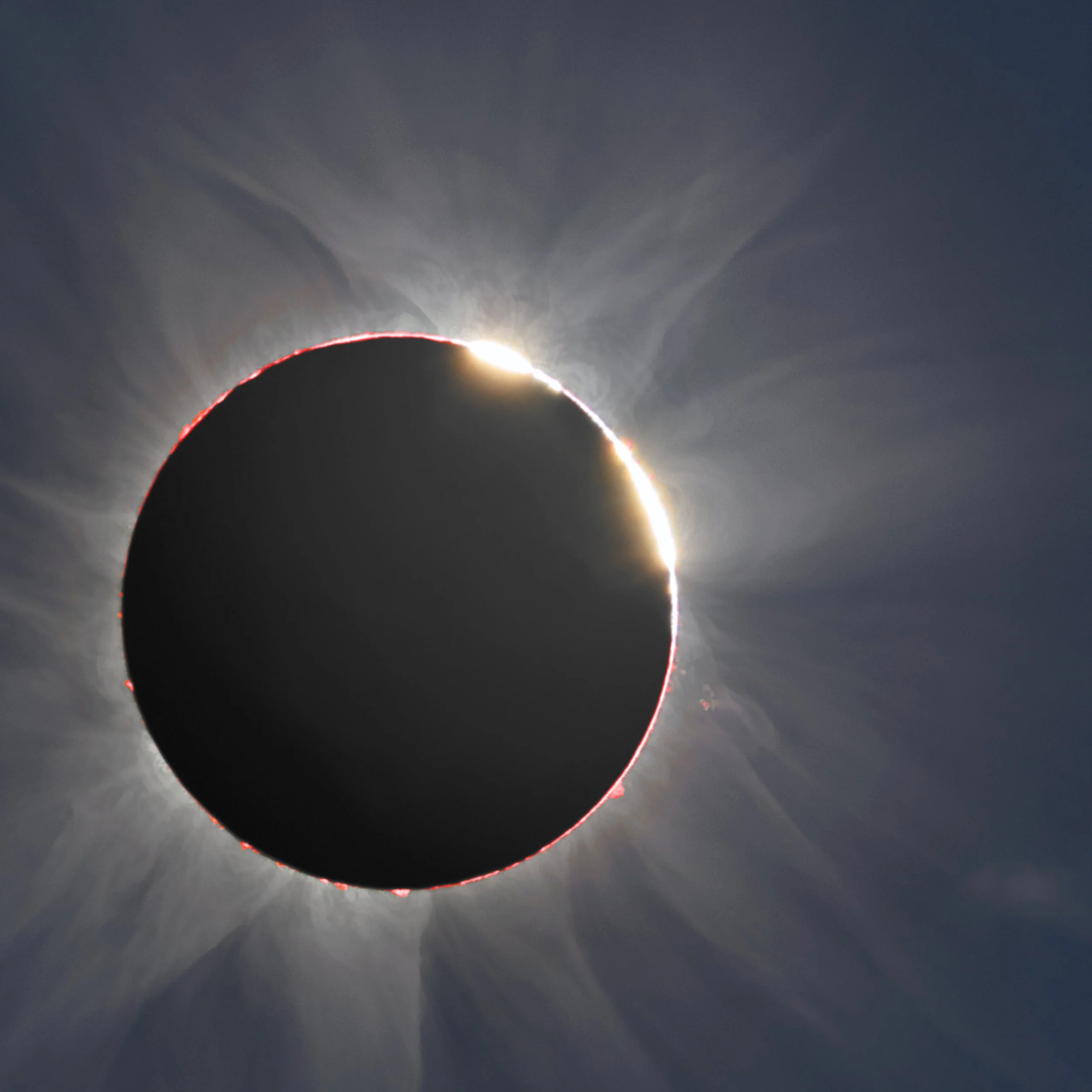
Photo showing the double diamond ring captured at the total solar eclipse of November 3, 2013 in Africa.
Credit: P. Horálek, J. Sládeček and M. Druckmüller. More images like this at http://www.zam.fme.vutbr.cz/~druck/Eclipse/index.htm
Of all the phenomena you will witness during a total solar eclipse, the diamond ring effect will be perhaps the most striking sight. The diamond ring effect occurs just as the last bit of exposed Sun is extinguished before totality and also at the moment when totality ends and the Sun reappears. While the diamond ring effect will be very brief, it will be one of the most lasting memories you will have from the eclipse.
Sometimes, the diamond ring effect presents a double diamond ring! That is, you’ll witness two brilliant bits of the Sun being simultaneously extinguished at the beginning of total eclipse, or two brilliant bits appearing when the Sun returns at the end of totality.
Just before the diamond ring effect, you may see a train of fine bits of sunlight - called Baily’s Beads - which quickly vanish one by one until only one bead is left. Using precise elevation models of the Moon’s irregular topography, we can now can predict just where the Baily’s Beads converge to two beads instead of one, creating the phenomena we know as the double diamond ring.
Using the double diamond ring maps
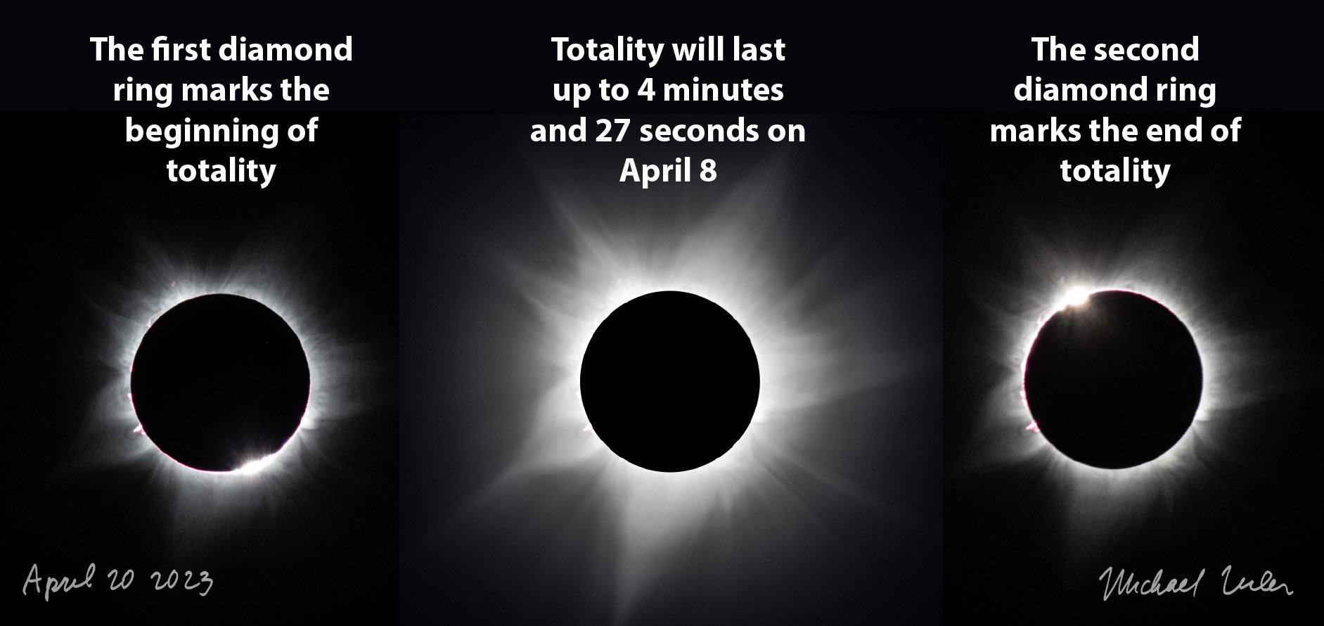
Photo of the diamond ring effect at the beginning and end of total solar eclipse. You must be inside the path of totality to witness this effect.
First, some perspective. The double diamond ring effect is striking, but just one of many phenomena you will experience inside the path of totality. We recommend that you seek the double diamond ring only if you are near the center of the path of totality and its location is near an observing site you would otherwise choose. Don’t sacrifice significant duration of precious totality, but if you’d like to catch this unique sight and especially if you’d like to capture a photograph of this striking phenomena, then go for it!
Further, these maps are meant as guidelines to find the location of the double diamond ring either at the beginning or end of totality. The scale of these maps is not sufficient to reliably pin down an exact location, so we recommend that after you find a candidate location, use one of several excellent eclipse-oriented apps and websites to verify a precise location. We discuss the follow-up apps and websites and explain the technical details on how these predictions were made at the bottom of this page.
Gallery of double diamond ring maps
We present a gallery of 14 maps across North America with our predictions on where you may experience a double diamond ring either at the beginning or end of totality. The green lines predict where you may see the double diamond ring at the beginning of totality. The blue lines predict where you may see the double diamond ring at the end of totality. Click on any map to enlarge to view a full resolution display.
Just below Mazatlan is a location where you might see the double diamond ring at both the beginning and end of totality! This is where you see the green and blue lines nearly coincident.
Near the locations of about 4 minutes and 25 seconds of totality, the green and blue lines are again nearly coincident.
A few miles north of Eagle Pass, Texas is a prime location to see two double diamond rings!
If you go to Kerrville or Fredericksburg, the double diamond is nearby. But the blue and green lines start to converge so you’ll have to make a choice. People who watch the total solar eclipse from San Antonio and Austin also have a great opportunity to witness the double diamond ring.
We don’t predict an obvious double diamond ring in the Dallas vicinity, but this chance exists near Waxahachie, Ennis, Terrell, and Sulphur Springs.
The highway between Russellville and Conway has several prospects. Hot Springs and Little Rock also might spy the double diamond ring.
Poplar Bluff, Carbondale, and Marion offer some possibilities to view the double diamond ring.
Vincennes, Bloomington, and New Castle are promising locations.
Wow! The southern shore of Lake Erie at Cleveland neatly follows the line of double diamond ring at the end of totality. Wapakoneta has a nice view at the beginning of totality.
Two good possibilities exist in the Buffalo metro area for beginning and end of totality. The northern suburbs of Rochester get a great view at the end of totality.
Just north of Plattsburgh gets the double diamond ring at the end of totality. Watertown is between two lines for the beginning and end of totality.
Houlton, Maine is close to the centerline of eclipse and has a good opportunity at the end of totality.
Two good possibilities for the double diamond ring exist in the northern tip of Prince Edward Island.
Newfoundland has several good opportunities at the end of totality, but these appear to not be near any sizable towns.
Advice for seeking the double diamond ring
If you wish to find your location for the double diamond ring, we suggest you start with these maps as a first step and then refine your precise location using one of these excellent websites and apps. If you are a photographer or eclipse enthusiast, you may already have Solar Eclipse Maestro or The Photographer’s Ephemeris apps for smartphones or Macs. Both of these apps provide detailed simulations of the Baily’s Beads which you may use to verify and determine exact locations. Another choice is the excellent eclipse simulator you’ll find at eclipse2024.org. An option for Android users is also given below.
https://photoephemeris.com/eclipses is an app that works on iOS. The Photographer’s Ephemeris also gives good guidance on finding your location at https://photoephemeris.com/articles/searching-for-the-double-diamond-ring or https://app.photoephemeris.com
http://xjubier.free.fr/en/site_pages/solar_eclipses/Solar_Eclipse_Maestro_Photography_Software.html is an app that works on MacOS. Note that it operates only on older versions of MacOS.
https://eclipse2024.org/eclipse_cities/statemap.html is a website with excellent simulators and an easy choice to use if you don’t wish to download an app.
Android users can download this app to show Baily’s Beads, https://play.google.com/store/apps/details?id=calcEclipsi2.src
For eclipse geeks only
An early eclipse map applying lunar limb corrections for the total solar eclipse of November 3, 2013. Click to enlarge.
Some people with a technical background will wonder how these maps were created. In 2011, Michael Zeiler of greatamericaneclipse.com pioneered the first eclipse maps that display the precise durations of totality corrected for the Moon’s irregular topography.
Shortly after the Japanese lunar orbiter Kaguya released its first lunar elevation models derived from its laser altimeter, Dave Herald, creator of Occult software (lunar-occultations.com/iota/occult4.htm), reduced a set of precise lunar limb profiles for a range of lunar libration values. Dave kindly shared these profiles and then Michael Zeiler and Bill Kramer (eclipse-chasers.com) collaborated to do the remaining calculations to apply these lunar limb corrections for eclipse maps.
Soon after, Michael Zeiler collaborated with Xavier Jubier (xjubier.free.fr) to optimize this process so that a very dense set of points with latitude/longitude values as well as eclipse circumstances can be processed to produce detailed GIS surface models from which the eclipse features on all the eclipse maps on this website were derived.
If you enlarge the eclipse map from the 2013 eclipse, you’ll notice some interesting features. Instead of the characteristic oval shape (representing the umbra) as displayed on classical eclipse maps, the umbral oval is instead is an umbral polygon with chords in a shape known to mathematicians as a convex hull. After some reflection and consultation with eclipse experts, Michael Zeiler determined that each of these chords represent the influence of a single Baily’s Bead in producing the diamond ring effect at 2nd and 3rd contacts of eclipse.
So what happens at the vertex between adjacent chords on the umbral shadow polygon? Logically, this represents a transition from the influence of one Baily’s Bead to another. So this transition marks the point where an observer will witness a double diamond ring! The double diamond ring prediction maps on this map were created by drawing lines that connect these transition points.
Note that these inflection points are joined at angles from shallow to more acute angles. Michael asserts that there is a relationship between the angle between each chord, and the angular separation of the two Baily’s Beads in a double diamond ring, as projected on a plane normal to the axis of the umbral shadow cone. Perhaps a direct relationship.
For maps of annular solar eclipses, we see the same convex hull shapes for the antumbral shadow. But Michael has a different interpretation for those: each chord in the antumbra is defined by a lunar mountain top, not a lunar low point as for total solar eclipses. The vertex between each chord makes an “anti-double diamond ring”, that is, the annulus at 2nd or 3rd contacts is interrupted by two high points on the lunar limb touching Sun’s limb (instead of one high point touching).
Shortly before the 2017 total solar eclipse, Ernie Wright of the NASA Scientific Visualization Studio (science.nasa.gov/sciact-team/scientific-visualization-studio/) independently produced similar lunar limb corrected umbral figures. Michael and Ernie compared their results and found good agreement despite a different computational process.